

Introduction
In today’s digitally driven marine industry, navigating the open sea is no longer just about experience and instinct — it’s about smart, real-time data. Enter the marine chartplotter: an essential navigation tool that has revolutionized how sailors, commercial mariners, and recreational boaters explore the water.
With advanced mapping, GPS, radar overlays, and integration with sonar and autopilot systems, chartplotters have become the digital nerve center of modern vessels. As maritime safety, connectivity, and efficiency grow in importance, the marine chartplotter market is riding a strong wave of growth.
Market Overview
Valued at over USD 1.7 billion in 2025, the global marine chartplotter market is expected to register a CAGR of 5–7% through 2031. Several factors are driving this growth:
- Rising demand for recreational boating and yachting
- Increasing emphasis on maritime safety and regulation compliance
- Integration of AI, real-time weather, and augmented reality in chartplotters
- Advancements in touchscreen and multi-functional display technologies
Whether you're navigating a small fishing boat or a mega-yacht, the chartplotter is becoming a must-have marine asset.
What is a Marine Chartplotter?
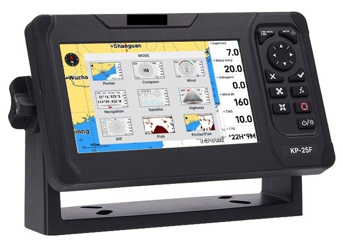
A marine chartplotter is an electronic device that displays a vessel’s location on a digital nautical chart, using GPS coordinates. Often combined with sonar/fishfinder systems, radar, and AIS (Automatic Identification System), modern chartplotters allow users to:
- Plan and follow routes safely
- Avoid hazards like shallow waters, rocks, and restricted zones
- Monitor weather and currents in real-time
- Identify other vessels and stay compliant with collision avoidance protocols
- Store and share waypoints and fishing data
Many high-end units now integrate with mobile apps, cloud storage, and satellite communication, turning vessels into smart, connected platforms.
Key Market Segments
Technology Trends Shaping the Market
- Touchscreen MFDs (Multi-Function Displays): Sleek, intuitive displays that consolidate radar, sonar, AIS, and engine data into a single dashboard.
- Augmented Reality Overlays: Visual overlays of markers, hazards, and data points through onboard cameras, enhancing situational awareness.
- Cloud-Based Route Syncing: Allows seamless syncing of charts and routes between devices and apps, ideal for fleet managers and travelers.
- AI-Powered Navigation: Some chartplotters now use predictive routing and suggest optimal paths based on real-time weather and tide data.
- Integration with Mobile Devices: Remote control, route planning, and live vessel tracking through smartphones and tablets.
Challenges in the Market
- High Cost for Advanced Systems: Premium chartplotters can be expensive for casual users or small fishing operators.
- Learning Curve: Despite growing user-friendliness, advanced systems may still require training for optimal use.
- Data Reliability: Real-time data accuracy, especially in remote regions, remains a concern for mariners.
- Cybersecurity Risks: Increasing connectivity raises concerns about vulnerabilities to digital threats, especially in commercial and defense applications.
Leading Players in the Market
- Garmin Ltd.
- Navico (Simrad, B&G, Lowrance)
- Raymarine (FLIR Systems)
- Furuno Electric Co., Ltd.
- Humminbird (Johnson Outdoors)
- Standard Horizon
- Koden Electronics
These companies are at the forefront of innovation, pushing boundaries in user experience, AI integration, and multi-network device compatibility.
Regional Insights
- North America & Europe: High adoption in recreational boating and fishing, supported by mature marine infrastructure.
- Asia-Pacific: Growing demand from commercial shipping and emerging recreational boating markets in China, Japan, and Southeast Asia.
- Middle East & Africa: Driven by increasing maritime trade and coastal surveillance initiatives.
The Future of Marine Navigation
As vessels become more autonomous and interconnected, marine chartplotters are evolving into comprehensive command centers. The integration of machine learning, real-time analytics, and satellite IoT is making maritime navigation smarter, safer, and more efficient than ever before.
In the near future, expect to see chartplotters fully integrated into broader marine digital ecosystems — linking fuel efficiency systems, environmental monitoring, and predictive maintenance tools into one seamless interface.
Conclusion
The marine chartplotter market is steering toward a connected and intelligent future. Whether you're charting unknown waters or managing an entire fleet, the modern chartplotter is the key to safer voyages, smarter decisions, and a more enjoyable experience on the water.
As marine industries ride the wave of digital transformation, chartplotters are no longer a luxury — they’re the heartbeat of next-gen marine navigation.



The global marine chartplotter market is estimated to register a CAGR of nearly 12.01% during the forecast period.Marine Chartplotter MarketMarine Chartplotter Market Market HighlightsThe global marine chartplotter market is expected to witness phenomenal growth during the forecast period due to increasing adoption of SONAR systems for search and rescue operations and rising use of anti-submarine warfare systems.
Furthermore, the upgrade of existing boats with devices such as marine chartplotters is expected to encourage market growth during the forecast period.
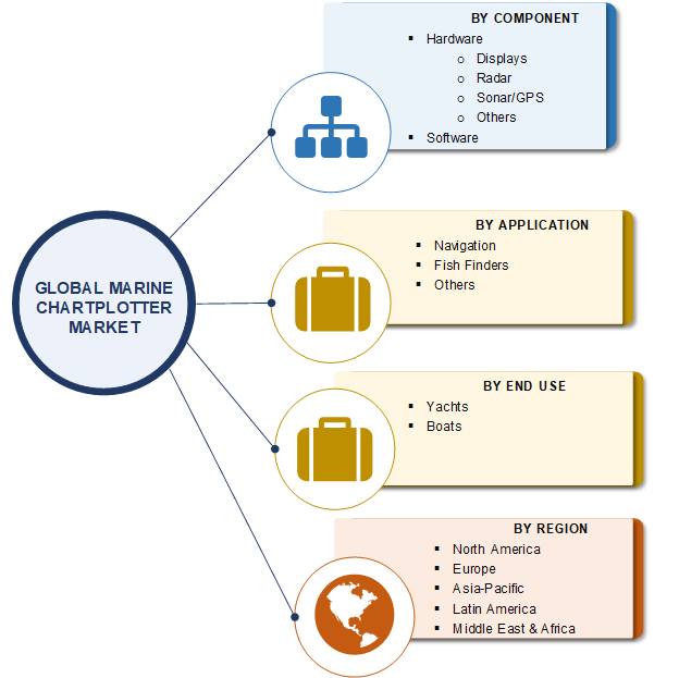
Chartplotter systems help in the detection of fish, which, in turn, is expected to drive the market growth during the forecast period.The global marine chartplotter market has been segmented on the basis of component, application, end use, and region.Based on component, the market has been segmented into hardware and software.
Hardware was a larger segment in 2018, while software is projected to be the faster-growing segment during the review period.
The hardware segment includes displays, radar, sonar/GPS, and others.
The sonar/GPS sub-segment is expected to register the highest CAGR during the forecast period.