


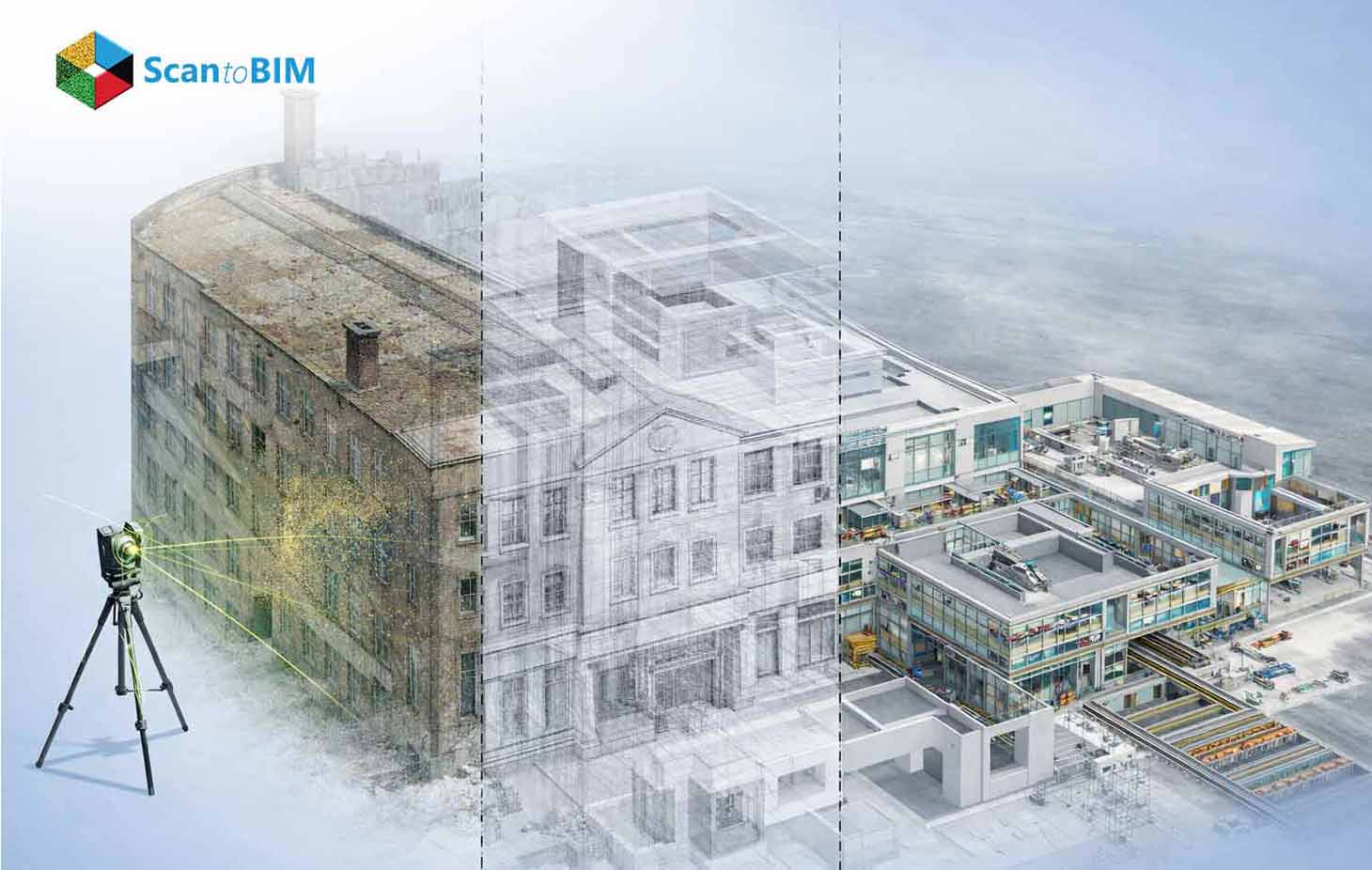
Reality capture technology plays a central role in modern AEC construction workflows. Scan to BIM converts high resolution 3D laser scans or LiDAR point cloud datasets into intelligent building information models used for design coordination, documentation, and facility planning. Survey teams capture millions of spatial measurements that represent actual building geometry. Specialists then translate those measurements into structured BIM elements. The resulting model represents real world conditions with high precision and becomes a dependable foundation for planning, renovation analysis and infrastructure decision making across complex built environments.
Large technically demanding projects depend heavily on this methodology. Hospitals, airports, industrial facilities, heritage structures and multi building campuses require accurate representation of existing conditions before engineering work begins. The workflow starts with field data acquisition through TLS Laser scanners, mobile LiDAR units or photogrammetry platforms. Processing teams then register multiple scans into a unified spatial dataset. BIM specialists interpret the point cloud and build parametric geometry using platforms such as Revit. Dedicated validation procedures compare modeled elements against scan references to confirm dimensional accuracy across architectural, structural, and mechanical systems.
Large facilities introduce additional complexity that intensifies scan to BIM challenges during project execution. Dense mechanical networks, irregular structural layouts, and massive scanned datasets increase modeling effort. Teams must interpret incomplete geometry, coordinate multiple disciplines, and maintain precise spatial alignment.
When executed through disciplined workflows, LiDAR to BIM delivers measurable value for design coordination, renovation planning, and facility operations. Accurate digital models reduce construction uncertainty, improve project decision making and support long term asset management across large-scale built environments.
Why Large and Complex Buildings Present Key Challenges
Large facilities create demanding environments for reality capture and BIM conversion. Construction Projects extend across vast floor areas with interconnected corridors, equipment zones and service spaces. Each zone requires multiple scan positions to capture accurate geometry, increasing data volume, coordination effort and processing complexity during modeling workflows.
These operational conditions highlight the importance of scan to BIM for complex buildings. Modeling teams must interpret dense spatial datasets, overlapping building systems, and irregular layouts across extensive facility environments.
Massive Data Volumes
Large facilities generate extremely dense point cloud datasets that frequently reach hundreds of gigabytes or even terabytes. Terrestrial scanners capture millions of points every second across numerous scan positions. Processing teams must register, segment, and manage billions of spatial measurements through advanced computing infrastructure and optimized data workflows.
Nonlinear Architectural Geometry
Complex buildings often contain irregular structural grids, curved facades, atriums and ceilings. Historic structures introduce ornate details and non-uniform surfaces that diverge from standard BIM components. Modeling specialists analyze these geometries carefully and construct accurate digital representations that reflect the true physical conditions of the structure.
High Density MEP Infrastructure
construction buildings contain tightly packed MEPF systems above ceilings and within service corridors. Several MEP services overlap within constrained spaces. Accurate 3D BIM modeling of these networks supports Conflict detection, renovation/retrofit planning and engineering coordination across multiple disciplines.
Restricted Access Zones
Many facilities include spaces that limit scanner placement. Crawl spaces, rooftop service areas, mechanical shafts, and equipment rooms create accessibility constraints for scanning teams. Technicians deploy varied scanning equipment and carefully planned capture strategies to record geometry within confined or elevated areas.
Occlusion Challenges
Occlusion occurs when structural elements, equipment or environmental conditions block the scanner's line of sight. Machinery, storage racks, and structural columns often conceal building surfaces. These obstacles create missing geometry inside the point cloud dataset and increase interpretation effort during BIM modeling workflows.
Major Scan to BIM Challenges in Complex Facilities
Large facilities introduce operational and technical complexities during modeling workflows. Dense datasets, irregular structures, and system overlaps often create recurring scan to BIM issues that influence accuracy, data processing effort, and project delivery timelines.
Data Occlusion in Dense Environments
Industrial machinery, structural frames, storage systems, and pipe racks frequently block laser scanner visibility in dense environments. Occlusions prevent full surface capture and produce incomplete point cloud regions. Modelers must reconstruct missing geometry through surrounding references and engineering interpretation, increasing modeling complexity and validation effort.
Interpretation of Unstructured Data
Point clouds contain geometric coordinates without semantic meaning. Modeling teams analyze raw spatial points to identify building elements such as walls, structural beams, mechanical pipes, and equipment systems. This interpretation process requires specialized BIM expertise and strong understanding of construction assemblies.
Registration Across Large Areas
Large campuses require hundreds of individual scans captured across multiple floors and zones. These scans must align through survey control networks or cloud-to-cloud registration methods. Minor alignment deviations across long corridors or vertical levels can produce spatial inaccuracies within the final BIM model.
Structural Irregularities
Existing structures frequently diverge from original design documentation. Renovations, structural deflection, and historical construction variations introduce irregular alignments and non-standard geometry. BIM specialists must represent these conditions accurately, often through custom modeling methods rather than standard BIM library components.
Hidden Building Systems
Subsurface utilities, concealed structural members, and enclosed mechanical services frequently remain invisible during scanning operations. Since scanners capture exposed geometry only, teams analyze historical drawings, engineering documentation, and investigation data to represent hidden infrastructure during BIM development.
Software Interoperability
Reality capture workflows involve multiple software platforms and data formats such as E57, LAS, RCP, and IFC. Data conversion between processing tools and BIM platforms introduces compatibility risks. Careful data validation maintains geometric precision and consistency across the modeling environment.
Technical Risks in Large-Scale Scan to BIM Projects
Large reality capture initiatives introduce technical risks that influence model precision and project timelines. These risks appear throughout the Point Cloud to BIM Process, from field scanning and data registration to processing, modeling, and final validation.
Digital Drift in Long Corridors
Long corridors and tunnel-like environments create cumulative alignment drift during scan registration. Small positional deviations across sequential scans gradually shift geometry from its true location. Survey control networks and reference targets anchor the dataset and help maintain spatial accuracy.
Multi-Level Registration Complexity
Multi-story buildings introduce alignment challenges across floors and vertical shafts. Scans captured on different levels must register through shared control points and consistent coordinate systems. Poor alignment may generate duplicate geometry or positional offsets between architectural and structural components.
Sensor Noise in Mobile LiDAR
Mobile LiDAR systems capture large environments rapidly through motion-based scanning. Moving people, dust particles, and environmental disturbances introduce noise and outlier points within the dataset. Processing workflows filter these artifacts before modeling to maintain reliable geometric representation.
Reflective Surface Distortion
Reflective materials frequently appear within industrial and commercial facilities. Stainless steel pipes, polished equipment, bright sunlight, and shadow conditions influence laser measurements. These factors scatter scanning signals and create distorted points that require filtering during point cloud processing.
Data Storage and Processing Constraints
Large scanning campaigns generate datasets that may reach hundreds of gigabytes or several terabytes. Managing these files requires high capacity servers, cloud storage platforms and powerful computing infrastructure capable of handling dense spatial information and complex modeling operations.
Hardware Selection Impact
Processing massive point cloud datasets requires high performance workstations equipped with advanced GPUs, memory capacity and fast storage drives. Hardware limitations slow data processing and modeling tasks. Selecting appropriate scanning equipment and computing infrastructure supports accuracy compliance with project tolerance standards. Beyond technical challenges, modeling precision is largely influenced by the Level of Development (LOD) defined for each system.
Impact of LOD and Project Scope on Complex Buildings
Level of Development defines the geometric accuracy and information depth contained in BIM models generated from reality capture datasets. LOD planning influences modeling effort, processing time, and data storage requirements. Engineering teams frequently adopt structured LOD strategies in scan to BIM hospital projects, where complex MEP networks and clinical infrastructure require precise representation for renovation planning, facility coordination, and operational analysis.
LOD 200 for Architectural Shells
LOD 200 models capture the primary architectural envelope including walls, floors, roofs, and structural grids. This level supports spatial understanding and layout planning. Moderate detail reduces computational load and storage demands, allowing large facility models to remain efficient for navigation and coordination.
LOD 300–350 for Critical Interfaces
This type of infrastructure zones require higher modeling precision. Mechanical rooms, equipment platforms and service corridors benefit from LOD 300–350 geometry that accurately represents pipes, ducts and cable trays. Detailed modeling allows clash detection, retrofit analysis and engineering coordination.
Targeted LOD Strategy for Healthcare Facilities
Healthcare environments contain dense service networks above operating theaters, laboratories and imaging departments. Targeted LOD strategies prioritize accurate modeling of mechanical and electrical infrastructure in these areas to support equipment installation planning and clinical facility upgrades.
Scope Control in Large Projects
Over modeling increases computational demand and creates heavy BIM files that slow project workflows. Strategic scope definition helps teams identify critical systems that require detailed representation, balancing modeling effort with project objectives and maintaining efficient model performance.
Alignment with BIM Standards
Modern BIM execution plans define modeling tolerances, information requirements and deliverable standards. Alignment with ISO 19650 information management frameworks and BIMForum LOD definitions supports consistent data structures, coordinated project collaboration, and reliable BIM deliverables across stakeholders.
Cost and Timeline Implications in Large Projects
Large-scale reality capture initiatives demand significant financial investment across scanning operations, software platforms, and computing infrastructure. High accuracy 3D laser scanners, LiDAR equipment and licensed processing tools require ongoing operational expenditure. Skilled specialists conduct field scanning, point cloud processing, BIM modeling and validation which collectively influence project cost structures.
Large facilities generate massive datasets that require extensive processing, cleaning, and registration before modeling begins. These workflows increase labor requirements and computational demand during the modeling phase. Complex geometry, irregular structural conditions, and dense mechanical systems extend manual modeling time and verification procedures. Additional effort occurs during quality validation to confirm geometric accuracy against point cloud references. Delays in data processing or scan alignment may influence project schedules and affect renovation planning, engineering coordination, and construction decision timelines. Many organizations therefore partner with specialized service providers that offer dedicated infrastructure and experienced modeling teams.
Scan to BIM Cost in 2026
Industry benchmarks indicate that Scan to BIM Cost in 2026 varies according to facility scale, LOD requirements, and point cloud density. Large campuses with extensive mechanical infrastructure require longer modeling cycles, advanced computing resources, and extensive quality validation. Modeling activities now represent a significant portion of project expenditure because interpreting high-density spatial data requires specialized expertise. Many organizations therefore adopt point cloud to BIM modeling services delivered by experienced teams that operate scalable processing environments, enabling efficient handling of complex datasets and accelerated delivery of accurate BIM models.
Explore real-world examples where laser scanning and BIM modeling improved facility management and renovation planning. View project case studies →
Best Practices for Overcoming Scan to BIM Challenges
Strategic workflow design and disciplined data management methods significantly reduce scan to BIM challenges in large reality capture projects.
Pre-Scan Site Verification
Technical teams conduct site verification before scanning campaigns to establish survey control networks, identify reflective surfaces, and map equipment density zones. This preparation defines scanner placement grids and minimizes capture gaps across large industrial or healthcare environments.
Hybrid Reality Capture Strategy
Large facilities require combined scanning methods. Terrestrial scanners deliver millimeter level accuracy for mechanical zones, mobile LiDAR captures long corridors quickly and drone photogrammetry documents across expansive campuses.
Automated Feature Extraction
Machine learning detection engines identify planar surfaces, cylindrical pipes, structural members, and equipment geometry directly within point cloud datasets. Automated classification accelerates BIM creation and reduces manual interpretation effort during large facility modeling workflows.
Data Segmentation Workflows
Large point cloud datasets undergo segmentation based on floor plates, service corridors, and equipment zones. Structured segmentation reduces memory load during processing and allows parallel modeling workflows across distributed BIM production teams.
Rigorous Quality Validation
Deviation analysis compares BIM geometry against point cloud references using tolerance thresholds defined in the BIM execution plan. This process identifies alignment deviations and validates dimensional accuracy before final model delivery.
Cloud Based Collaboration
Modern reality capture projects operate inside cloud based common data environments aligned with ISO 19650 workflows. Centralized storage allows distributed teams to process, validate and coordinate large point cloud datasets efficiently.
Choosing the Right Scan to BIM Company for Complex Buildings
Selecting the right Scan to BIM service provider requires deeper technical evaluation than a standard BIM outsourcing decision. Large facilities generate multi terabyte datasets that demand specialized capture planning, high-capacity processing infrastructure, and disciplined modeling workflows. Providers must demonstrate experience in scanning active environments such as refineries, airports, and operational hospitals where equipment density and restricted access complicate capture strategies. Firms experienced in scan to BIM industrial facilities usually operate structured survey control methods, advanced registration workflows, and hardware fleets that combine terrestrial scanners with mobile LiDAR systems to maintain consistent spatial accuracy across extensive facility environments.
Project owners should also analyze how the provider handles modeling complexity after scanning. Converting dense point clouds into coordinated BIM deliverables requires specialists who understand construction assemblies and mechanical infrastructure. Experienced teams develop custom parametric families for irregular equipment, structural distortions, and legacy building elements. High-performing firms offering BIM modeling for large facilities maintain production pipelines that divide datasets into logical zones, allowing parallel modeling across architectural, structural, and MEP disciplines. Their QA procedures often include tolerance based deviation analysis, clash verification, and model validation aligned with BIM execution plans.
Infrastructure capability represents another critical differentiator. Large reality capture projects demand scalable storage environments, GPU accelerated workstations, and cloud processing frameworks capable of managing billions of spatial data points. Professional providers implement ISO 19650 information management protocols that control data versioning, metadata organization and secure access for distributed teams. Mature providers also demonstrate disciplined communication frameworks, phased delivery strategies, and transparent coordination workflows that align BIM outputs with engineering milestones. This level of operational maturity allows complex reality capture projects to move from raw spatial data toward reliable digital twin environments used for long term facility planning.
Conclusion: Delivering Accurate BIM for Large Facilities
Point Cloud to BIM modeling services now functions as a critical foundation for accurate digital twins in large operational facilities. Airports, hospitals, manufacturing plants and research campuses depend on reliable spatial intelligence before renovation, expansion or system upgrades begin. Large environments generate extremely detailed point cloud datasets and complex mechanical infrastructure that demand disciplined capture strategies and structured modeling pipelines. When survey control, point cloud registration and LOD planning align from the beginning of a project. BIM Experts can convert reality capture data into dependable BIM environments that reflect real construction conditions rather than idealized design assumptions.
Organizations that treat reality capture as a structured data workflow rather than a scanning task achieve better long-term results. Advanced modeling pipelines combine automated feature recognition, dataset segmentation, and tolerance based deviation analysis to maintain model reliability across multi-building campuses. These practices transform raw spatial measurements into operational digital twins capable of supporting retrofit design, asset tracking, and facility lifecycle planning. As AI assisted modeling, high performance cloud processing, and automated validation tools mature, large facilities gain faster access to high fidelity BIM environments that guide engineering decisions with measurable spatial accuracy.


