


Why Historical Geological Data Still Matters
Modern mineral exploration increasingly relies on satellite imagery, geophysical surveys, geochemistry, GIS, and machine learning. However, some of the most useful information may already exist in historical geological maps, exploration reports, mine records, drill logs, and field surveys.
Historical data can provide evidence about where previous geologists identified mineral occurrences, geological structures, alteration zones, prospects, and mining activity. The U.S. Geological Survey, for example, maintains extensive geological and historical map collections that contain information dating back to the 19th century. Its National Geologic Map Database provides access to more than 100,000 geologic maps and related reports.
1. Locating Historical Mineral Occurrences
Old geological maps can identify locations where mineralization, prospects, mines, adits, shafts, and other exploration features were previously recorded.
These records can serve as valuable starting points for modern exploration programs. USGS has digitized hundreds of thousands of mine and prospect features from historical topographic maps, creating geospatial datasets that show where exploration and mining activities occurred over time.
Instead of treating historical exploration as outdated information, exploration teams can use these locations as reference points for investigating broader geological trends.
2. Revealing Geological Patterns Over Time
Historical maps can help geologists understand how earlier surveys interpreted rock units, faults, folds, intrusive bodies, alteration zones, and other geological structures.
When older maps are georeferenced and combined with modern geological layers, differences between historical and current interpretations can also become apparent. This can help researchers reassess geological boundaries and identify areas that warrant additional investigation.
3. Combining Historical Data With Modern GIS
Digitization makes historical information significantly easier to integrate into modern exploration workflows.
Historical maps can be scanned, georeferenced, digitized, and converted into GIS layers. Once standardized, information such as mine locations, geological contacts, sampling locations, and structural features can be compared with modern satellite imagery, digital elevation models, geochemical surveys, and geophysical datasets.
USGS projects demonstrate how historical mine symbols can be converted into spatial databases suitable for mineral-resource research and mapping mineralized areas and systems.
4. Supporting Exploration Target Generation
Historical exploration records can provide evidence about areas that have already attracted geological interest. Old reports may contain descriptions of mineral occurrences, sampling results, drilling activity, production history, or unsuccessful exploration programs.
The historical record can therefore be used alongside modern datasets when developing exploration targets. USGS historical mineral-exploration files, for example, contain maps, reports, correspondence, exploration results, and information about properties investigated between 1950 and 1974. These records have been identified as useful for understanding potential and non-potential prospect areas.
5. Reassessing Previously Explored Areas
An area that produced limited results in the past is not necessarily irrelevant to modern exploration. Earlier programs may have been constrained by the technology, analytical methods, geological models, or exploration budgets available at the time.
Modern remote sensing, higher-resolution geophysics, improved geochemical analysis, and 3D geological modeling can provide new ways to interpret the same region.
Historical information can therefore provide context for understanding why previous exploration succeeded or failed while helping modern teams identify questions that were not addressed by earlier programs.
6. Preparing Historical Data for AI and Machine Learning
Historical geological information can also become valuable training and reference data for AI-driven exploration workflows but only after careful digitization, standardization, and validation.
India's National Geoscience Data Repository (NGDR), for example, is designed to bring legacy exploration data into a standardized, GIS-compatible format specifically to facilitate dissemination and the application of emerging technologies such as AI and machine learning.
Once appropriately structured, historical observations can potentially be combined with modern geological, geochemical, geophysical, and remote-sensing datasets for advanced spatial analysis.
Challenges When Using Historical Data
Historical records need to be treated carefully. Maps may use outdated coordinate systems, geological classifications, inconsistent scales, or terminology that differs from modern standards. Some records may also contain incomplete sampling information or uncertain locations.
Digitization does not automatically make historical information accurate. Geologists need to evaluate the original source, scale, methodology, spatial accuracy, and reliability before incorporating the information into a modern exploration model.
The Future of Historical Data in Mineral Exploration
The growing integration of legacy information with modern geoscience technologies creates an opportunity to extract additional value from decades of exploration activity. Historical maps can provide context, while satellite imagery, geophysics, geochemistry, GIS, and AI can add new analytical capabilities.
Modern mineral-resource programs increasingly use multiple data types—including geological, geochemical, geophysical, mining, exploration, remote-sensing, and spatial information—to develop a more comprehensive understanding of mineral potential.
Conclusion
Historical maps and exploration records remain valuable resources for modern mineral exploration. When properly digitized, georeferenced, validated, and integrated with current datasets, they can help locate historical prospects, reveal geological patterns, support target generation, and provide context for reassessing previously explored areas.
The key is not to replace modern exploration with historical information, but to combine legacy geological knowledge with modern GIS, remote sensing, geophysics, geochemistry, and AI benchmarking. This integrated approach can help exploration teams make better use of existing knowledge while identifying new questions and opportunities for future investigation.

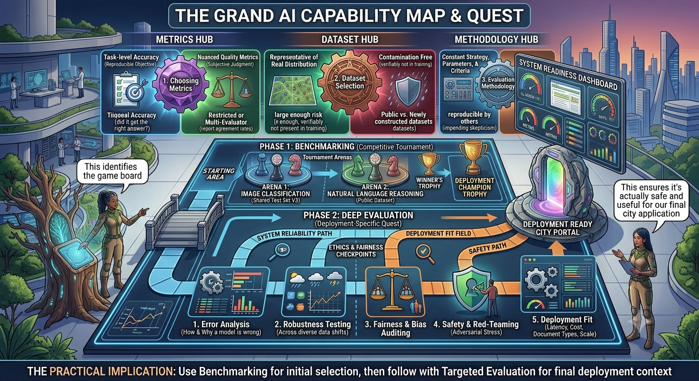
Three Interlocking Decisions
Setting up a rigorous AI model benchmark from scratch involves three interlocking decisions: what to measure, what data to measure it on, and how to run the com


The technical details of your computer can help you in knowing its capabilities, especially if you are planning to run a specific game.
Benchmarking software enables you to overclock your system and change the fan speed settings.In this article, we will mention some benchmarking software you can use for your computer:CPU ZCPU Z enables you to have a complete rundown of your system’s hardware details, especially regarding your CPU.
With CPU Z you can also save a TXT file via the “Tools” option.HW MonitorHW Monitor visualizes the model of the hardware components in your PC and also displays some live parameters like power consumption, utilization percentage, clock speeds, fan speeds, and temperature.
The monitoring of these components can be crucial to monitor some critical issues like overheating, which can eventually shut down your computer.
HW Monitor offers a simple yet intuitive interface that enables the users to view and understand all the values.
The SiSoftware Sandra Lite software can help you in testing your computer’s memory bandwidth, compare network performance, or compare your computer’s power efficiency.